
Driving Directions to Mission Base
Detailed Driving Directions
Things have advanced so much in technology, that driving to the mission base is extremely simple.
Just open Google Maps on your device and type in Go Missions to Mexico Mission Base.
If that is not an option for you then below we do have a detailed driving directions for getting to Go Missions to Mexico’s Mission Base.
Following are nicely done, detailed driving directions for getting to Go Missions to Mexico’s Mission Base. There is only one major highway running the length of the Baja Peninsula so getting lost is not much of a problem. There are basically just 4 turns you’ll need to make on your drive down. Each one is simple and outlined below.
Helpful Tips
There are several ways to get easy driving directions to the mission base.
1. The simplest way is to use Google Maps for navigating to the mission base. Just type in “Go Missions to Mexico Mission Base,” and you will have perfect directions for finding us. You will need to have your phone activated for data in Mexico for this to work.
2. If for some reason, you don’t have data availability while in Mexico, you can still use Google Maps to see where you are and where we are. You will see a small round blue dot that will show your location (you need to have your location activated on your phone).
3. You can also print directions from our website and hand them out to each driver. Please carefully read and look at them before your departure.
4. Take advantage of the Google Map to the right. You can enlarge it and zoom in if you’d like. You can also print off directions from it as well.
5. We provide these directions in a printable format as well. Just click on the link above. Printable directions will be of great help to have in your vehicles for your drivers.
6. If it looks like you’re running late, give a call before crossing the border so we know when your approximate arrival time will be.
7. There are photos and videos on the right column that provide extra help as well. Rest assured that driving to our area is very safe and easy.
Crossing the Border
As you prepare to cross the border, there’s an important tip you need to know. The vehicle in your team carrying your food, luggage, and main supplies, should go first. Mexico will generally check vehicles pulling trailers, cargo vans, etc., to see if you’re bringing items to sell in Mexico. If the vehicle carrying your food, etc. is stopped, then the rest of the vehicles should pull over as well so they know you’re all part of a team, and that the items in the cargo vehicles isn’t being brought to Mexico to sell (If they see a lot of food, etc., without people to go with it, they’ll assume it’s being brought to Mexico to sell). If the cargo vehicle goes last, and the passenger vehicles go first and are not stopped to be checked, then there won’t be any proof the cargo vehicle isn’t bringing these items to sell in Mexico.
From San Diego, you will go South about 15 miles. You can take either Interstate 805 or 5. They will both meet about a mile before the border. Always remember that you are just a tourist (Mexico has no category for short-term mission groups). It's best just to answer the questions asked you and not to tell them your life story and every detail you plan on doing in Mexico as this could lead to potential problems. Just the driver should speak, and all others should be respectful and quiet unless asked a question.
For a complete video tour to Go Missions to Mexico’s Mission Base, please see the video to the right.
Video Driving Tour to Mission Base
From the Border to the Toll Freeway
You will not enter Tijuana, but will bypass it on a freeway.
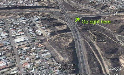
After you’ve crossed the border, you will see a sign above you and to the right that says, Rosarito, Playas de Tijuana, Cuota. Cuota means toll road. You’ll want to now get into your far right-hand lane and follow the signs that say Rosarito, Ensenada, and Cuota. You’ll shortly exit to the right and do a half circle putting you on a freeway that bypasses Tijuana and links you up to the toll road headed south to Ensenada. Please see the video to the right.
You'll follow this freeway for about 3 miles and will come to a very steep upgrade. On the other side of the hill, as you approach the bottom, there will be an exit for Ensenada/Rosarito, toll road (cuota). Exit to the right. Please see photo to the right.
Main Border Crossing & Getting on the Toll Road
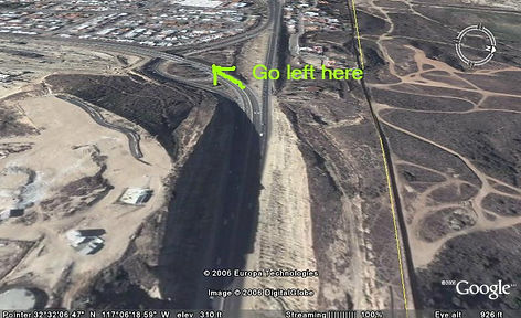
About 3 miles after the border you will climb a steep hill, on the other side at the bottom of the hill you'll take a right and intersect with another freeway. Follow signs to "Ensenada, Rosarito, Cuota, Scenic Route"
Continue on for about another 2 miles (about 5 miles from the border) and the freeway will split with two lanes going to the right and two to the left. You want to get into the left lane and prepare to take the freeway that veers to the left. After this point, you'll be on the toll freeway from Tijuana to Ensenada which is also called, "Cuota," "Ensenada/Rosarito," and "Highway 1." Please see photo to the right.
You’ll have 3 toll booths between Tijuana and Ensenada. Each toll will cost around $2.00 per vehicle (slight more for buses, vehicles pulling trailers, etc.)
About 5 miles from the border, and 2 miles from your last turn, you'll take a left on another freeway (make sure you get in your left lane prior). Follow signs to "Ensenada, Rosarito, Cuota, Scenic Route" Your now officially on the toll road and safely headed south towards Ensenada. You'll have 3 toll booths between Tijuana and Ensenada. Each toll will cost around $2.00
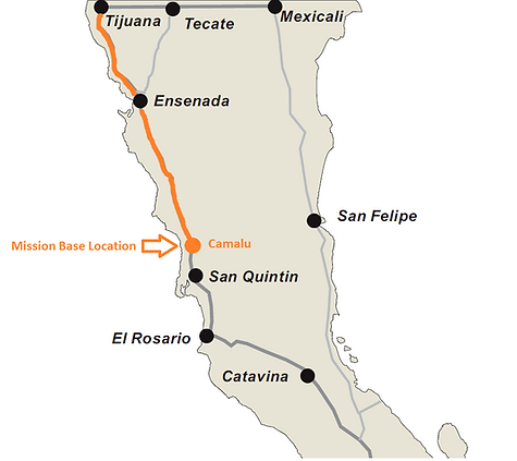
From Tijuana to Ensenada
70 Miles
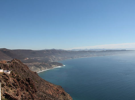
This is a freeway and is very beautiful and scenic. There will be breathtaking views of the ocean as you drive along. It's a freeway with three toll booths that will charge about $2.00 per vehicle (a little more if you're pulling trailers or bringing a larger vehicle).
Going Through Beautiful Ensenada
Follow the signs to, "San Quintín." Ensenada is quite large, and it will take about one half hour to go through it (because there are several bedroom communities). There are two ways to go through the first part of Ensenada and the way via the Tourist Zone is the best and fastest. About 5 miles after the third toll booth the freeway will split, and you'll want to stay to the right. The way to the left takes you through more of the city as the way to the right takes you through the Tourist Zone.
As you enter the Tourist Zone (several miles after the freeway splits), you'll notice on your right a park with 3 heads and a large Mexican flag. Continue on and about 1 mile after the park with 3 heads, you'll want to take a left (be sure to merge into your left lane as you progress on). This left turn will be at an intersection with stoplights. You'll notice on your left a Pemex gas station. This is a good marker. Go about another mile and you'll come to a large intersection. Take a right here. You'll notice on your left a large sign (mall type) listing the stores in this mall. One familiar one will be Office Depot. Take a right at this intersection.
If, for some reason you miss this turn, don't worry about turning around. You can continue south for about mile (to the second left turn) and turn left. It will take you up a couple of blocks to the main street. Take a right and you'll be on your way. You can also take other roads you see on your left.

From Ensenada to the Mission Base
70 Miles
There is no way to get lost here as there is no other paved road. Just follow the road to San Quintín. You'll note kilometer markers will start after you get out of Ensenada and are in the country. They'll start at 0 and will go up. There will be a marker every 2 kilometers.
About 50 miles after Ensenada there will be a soldier checkpoint. They are just checking for guns and drugs. They are your friends and exist for your protection. Don't be afraid or alarmed. You will be waived through or stopped and checked. Either way, they are kind and respectful.
Continue proceeding south towards the San Quintin Valley. The main pueblo (small town) in between Ensenada and San Quintín is San Vicente. This is located at approx. kilometer marker 80 or 90.
You'll start hitting a number of pueblos (this is where the Valley of San Quintín starts) at about kilometer 120 or 130. The Mission Base is located just after kilometer 162.
Arriving at Go Missions to Mexico’s Mission Base
Be sure to keep track of the Kilometer markers. They’re the key to knowing where you’re at.
You will arrive at a town called, “Camalu” just before arriving at the turn off to the Mission Base. The Mission Base is 3 miles after Camalu.
As you get close to the turn off to the Mission Base, you will see Kilometer marker 162. Just after Km. 162, you will see a white wall that surrounds a large compound. You will turn right just after the white wall.
After turning right, just go about 200 yards and you’ll see a red entryway with a sign above that says, “Rancho Casa de Luz.” That’s the name of the Mission Base.
